|

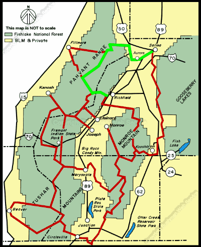
The ride from Salina to Richfield requires about tour and three
quarters hours. Within this section the intermediate times are as
follows:
Approximate Section Time
· Salina to Aurora ---------------------------------------------
0.5 hr
· Aurora to the Willow Creek Road ------------------------
1 hr
· Willow Creek road to Bear Hollow Road ---------------
1 hr
· Bear Hollow Road to Sand Rock Ridge Road ---------
1 hr
· Sand Rock Ridge Road to Cottonwood Canyon --- 0.25
hr
· Cottonwood to Forest Road 096 -------------------------
0.5 hr
· Junction with main trail to Richfield --------------------
0.5 hr
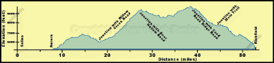
From the 5,160-foot elevation at Salina the trail rises slightly
then descends to its lowest elevation of 5,140 feet at the Aurora
bridge across the Sevier River. It then rises to 5,190 feet in Aurora.
In the foothills west of Aurora the trail rises to 6,400 feet on
the ridge north of Frogs Flat and continues up to 6,600 feet at
the mouth of Willow Creek Canyon. From there it climbs to 9,200
feet at the junction with the Bear Hollow Road near Indian Springs.
Across most of the Pahvant Range the trail is at about 8,800 feet,
but then it rises to 9,600 feet at the junction with the Sand Rock
Ridge Road near White Pine Peak, the top of which is about 10,200
feet. From the junction the trail descends to 7,600 feet at the
turn to the Richfield side loop. This loop descends to 6,600 feet
at Little Valley and then about 5,400 feet at Richfield.
continued next page
Last changes:
Thursday, December 09, 2010
|